|
|


Disaster Alert Systems
 This section of our technical library presents articles written about Emergency Alert Systems and Disaster Recovery definitions, terms and related information.
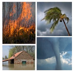
The 911Broadcast emergency notification and alert service can deliver a large number of phone calls using a network of phone systems employing digital phone lines simultaneously. Should a disaster such as a snow storm, wild fire or flood hit your area, 911Broadcast systems can alert your community quickly providing specific instructions if an evacuation is required.
This service is available using our emergency broadcasting systems. If a dangerous chemical spill occurs in your community, you can target specific areas to call. If a severe snow storm hits your area, your community can be notified of school closings or event cancellations.
Contact DSC Today for a FREE analysis and quote and to learn more about our emergency notification systems and services.
Predicting Winter Weather
Predicting winter weather: the weather never sleeps, inconsistency is the only constant
U.S. Air Force, Safety Agency
Pilots from Boston, Massachusetts, to Birmingham, Alabama, had no problem making go/no-go weather decisions 13 March 1993. For the first time since commercial aviation began, a blizzard had closed every airport from the Southeast to New England. Called the "Storm of the Century," it dumped more than a normal decade's worth of snow--17 inches--in Birmingham, Alabama. It gave Syracuse, New York, 43 inches. Snowfall rates of two to three inches an hour were common.
While some larger airports were closed less than a day, others needed days to clear the snow. Even if pilots had been able to get a clear runway, they wouldn't have wanted to take off. The weather station atop Mount Washington, New Hampshire, at 6,200 feet above sea level, recorded a gust of 144 mph. The wind at New York City's LaGuardia Airport was gusting to 71 mph.
The "Storm of the Century" also included "thundersnow." Anyone in the air would have faced the hazards of thunderstorms hidden in the clouds and snow. Aircraft also would have encountered heavy airframe ice. Central New Jersey reported 2.5 inches of sleet on the ground. Sleet on the ground means supercooled raindrops, or freezing rain, is somewhere above, and freezing rain creates the most dangerous kind of airframe icing.
While a "Storm of the Century" is rare, ordinary weather storms make life harder for pilots in many ways. While some weaker storms make it clear that flying isn't a good idea, most require pilots to make difficult choices without clear-cut information. Winter brings the strongest and biggest storms, because mid-latitude storms, those that form outside the tropics, draw energy from temperature contrasts. The greater the temperature differences between large air masses, the stronger a storm is likely to be.
Arctic temperatures begin plunging as the days grow shorter during fall and into winter. The tropics, however, stay warm because the days stay nearly the same length all year. Most of the contiguous 48 states become winter's battleground between frigid Arctic air and the balmy air of the tropics. The resulting weather can range from mild systems that cloud the skies and produce a little rain or snow to full-fledged blizzards. A blizzard, by the way, is a storm with snow falling while the wind blows at sustained speeds of 35 mph or faster near the ground and the visibility stays at or below .25 miles for an extended time.
As with any kind of dangerous weather, information is the pilot's first defense. Big storms don't appear by magic. Today's forecasts do a generally good job of saying when something big is brewing. But even with the best technology, forecasters have difficulty pinning down the details of winter storms.
In March 1993, the computerized forecast models in the U.S. and Europe pointed to a major East Coast storm six days before it began. Two days before the storm began, the computer forecasts agreed totally, and the National Weather Service began issuing storm warnings. The forecasts did not, however, point to some important details, such as snow as far south as the Florida Panhandle. The lesson for pilots? Stay abreast of the general weather picture even when you aren't flying.
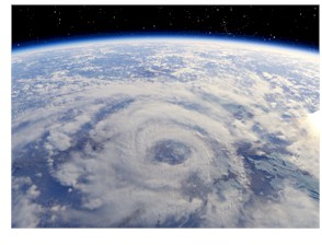
The "Storm of the Century" was an extratropical storm with a low-pressure center and warm and cold fronts, as shown in figure 1. Such storms account for a good share of the nation's bad winter weather, but not all of it. Many storms track across the U.S. from the Pacific to the Atlantic with their characteristics changing on the way. The storm's exact path also makes a big difference in the weather it causes.
A storm that moved across the United States from 13-16 February 1990 is a good example. It's one of the best-documented cross-country storms because it moved across regions, each with different scientific groups studying winter weather. Effects of the 1990 storm included:
- Heavy snow in the West, northern Plains, and New England, including snow that shut down Chicago's O'Hare Airport.
- Freezing rain from Oklahoma to New England.
- Severe thunderstorms with tornadoes and flooding in the South and along the Ohio River.
- Frost damage to citrus in California and Arizona.
- Damaging winds in California, New Mexico, Texas and Wyoming.
- Aircraft icing over much of the U.S. east of the Rockies, and north of the Ohio River and North Carolina.
Scientists are still studying the detailed observations made by researchers in Denver, Kansas City, Missouri, Champaign, Illinois, and western New York. The observations show that winter storms are complex and composed of layers of air at different temperatures. Bands of precipitation will bury some areas in snow and deposit freezing rain, rain, or almost nothing on nearby areas. Here's a very general picture of what to expect from winter storms in different parts of the country.
The West Coast to the Rockies. As storms move inland from the Pacific Ocean, they normally bring heavy rain to low-elevation coastal areas and snow to the mountains. Pilots used to Eastern or Midwestern weather must be prepared for huge differences over short distances. For example: Sacramento, California, averages a trace of snow in a year. South Lake Tahoe, California, less than 100 miles away in the mountains, averages 58 inches in January alone. Heavy snow also falls eastward to the Rockies. Another danger is turbulence as high winds flow through valleys and canyons and over mountains.
The Plains and the Midwest. The mountains break up low-level wind circulation in storms, but the storms tend to reform just east of the Rockies. As they grow, storms pull in cold air from the north and warm, humid air from the Gulf of Mexico. These contrasting air masses add energy. As a storm moves farther east, it taps more humid Gulf air, increasing the possibility for heavy snow. Slow-moving storms can bring hour after hour of wind and heavy snow.
The Southeast and the Gulf Coast. While winter weather isn't as common here as it is farther north, it can cause serious problems. Major ice storms hit Dallas and Atlanta every few years. Southern snow is often wet and heavy, and airports aren't as well equipped to clear away snow and ice as those farther north.
The Mid-Atlantic and the Northeast. Storms move into the eastern part of the country both from the Midwest and from the Southeast. Some of the worst are the storms that form or strengthen over the Gulf of Mexico--such as the March 1993 blizzard--and move up the Atlantic Coast, drawing in warm, humid ocean air. Midwestern storms often will weaken west of the Appalachians, but their upper-level circulation will move eastward and stir up "secondary" storms just off the Atlantic Coast. These "secondary" storms sometimes can be stronger than the original storm west of the mountains.
With a big picture of what storms can do, and the latest forecasts, pilots can begin assessing the dangers of a particular winter trip. The ideal time to fly is after a storm has passed through, bringing in cold, stable air and clear skies, but before the next storm begins stirring things up. The key to safe flying is knowing when the next storm is likely. Don't assume the 8 a.m. forecast is going to be good by 2 p.m., and don't assume that all bad winter weather comes with big, extratropical storms.
A group of University of Illinois scientists who studied winter storms summed up forecasting problems in the 1991 Bulletin of the American Meteorological Society. The 26 storm systems they studied over three years had precipitation that lasted from 30 minutes to 28 hours. The precipitation included heavy snow with five- to ten-inch accumulations accompanied by lightning and heavy freezing rain, some storms that were very cold, and some that were very warm with rain.
Such variability, they said, means "the prediction of the onset, duration, intensity, location, and type of precipitation often proves to be difficult and continues to be one of the most challenging problems in meteorology."
A lesson for pilots is that what is going on in one part of a storm is not a good guide to what is happening a few miles away. The current weather can quickly change as a winter storm, or even a band of clouds that is not part of a storm, moves along. Pilots need to be mentally prepared for conditions that are worse, or better, than forecast.
COPYRIGHT 2003 U.S. Air Force, Safety Agency
Severe Weather Warnings And Alerts Phone Service
 Should a severe weather condition occur in your area, our phone services can help warn your community. With our emergency notification phone service, you can broadcast warning messages to thousands of households in your community, warning of catastrophic disasters including severe weather and storms.
Messages can be simultaneously delivered in just minutes using our network of phone systems and services. Pre-recorded warning messages can be played giving households information regarding the severe weather location and whether a community evacuation is planned or necessary.
You can send a broadcast warning to specific neighborhoods or communities in the event of a severe weather storm and provide priority delivery of these messages to those nearest the severe weather disturbance. Multiple messages can be delivered to different members of the community based upon proximity to the weather alert.
Calls can be directed to operators that are standing by to handle special individual emergencies.
Messages can also be broadcast seeking volunteers or special assistance from emergency personnel.
 Other applications include warning residents when the danger of severe weather conditions is at a high level. Travel and activity restrictions can likewise be broadcast using this service.
Severe weather warning messages sent to households in this fashion can be simple warnings with specific or general instructions. If the community needs feedback from the call, an interactive response can be programmed into the message allowing the person to either acknowledge the call or to contact someone. Messages can vary based upon proximity to the event, with different degrees of broadcast warning and instructions.
To learn more about our severe weather and emergency response / disaster recovery phone service, please visit our Emergency Broadcast System web page.
Contact DSC Today for a FREE analysis and quote and to learn more about our emergency notification systems and services.
|