|
|


Emergency Response Systems
 This section of our technical library presents articles written about Emergency Alert Systems and Disaster Recovery definitions, terms and related information.
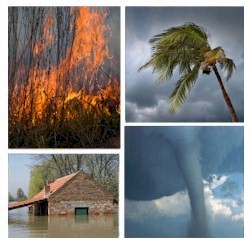
The 911Broadcast emergency notification and alert service can deliver a large number of phone calls using a network of phone systems employing digital phone lines simultaneously. Should a disaster such as a snow storm, wild fire or flood hit your area, 911Broadcast systems can alert your community quickly providing specific instructions if an evacuation is required.
This service is available using our emergency broadcasting systems. If a dangerous chemical spill occurs in your community, you can target specific areas to call. If a severe snow storm hits your area, your community can be notified of school closings or event cancellations.
Glossary of Winter Weather Terms!
Be Prepared for the Upcoming Winter Season!
Reprint: weathereye.kgan.com
1. Snow and heavy snow: If the word snow is heard during a weather forecast or weather report, it means that continuous snow is falling or expected to fall. Heavy snow is used to describe conditions when snowfalls will add up to 6 more inches in a 12 hour period or 8 inches or more in a 24 hour period.
Snow is dangerous to travelers since it causes the road to become slippery. One of the more dangerous times during Winter storms is when the road initially becomes snow covered. A thin layer of snow offers less traction than an inch or more. When traveling during a falling snow, remember to be especially careful when the road is first covered with snow. Snow often leads to other problems which will be described below.
2. Thundersnow: Major winter storms sometimes contain "thundersnow". Thundersnow is caused by vigorous clouds within the storm. Similar to thundershowers, thundersnow produces precipitation quickly and in greater amounts. It is common for locations to receive between 2 to 4 inches of snow per hour while thundersnow is occurring.
3. Rain or freezing rain: Though rain is more commonly associated with fall and summer storms, large and complex Winter storms often contain a mixture of elements. Depending on where you are in relation to the storm, you may receive rain, freezing rain, or snow. Sometimes you can receive all three from one storm and occasionally one or two types of precipitation may fall at the same time. This can complicate not only the forecast, but how likely it is for travelers to get through the storm!
Freezing rain will occur when the air aloft is warm enough for snow to melt into rain as it falls towards the surface. Once it hits the surface which needs to be below 32 degrees Fahrenheit, it will freeze on contact. Since ice is less dense than water, a half an inch of rain that freezes on contact, will actually lead to more than a half an inch of ice on the ground.
Freezing rain is extremely dangerous to travelers since it coats roadways with ice. This reduces the friction or "grabbing ability" that tires normally need to keep a car attached to the road. When you drive on ice, you are no longer on the road!
4. Sleet and Snow pellets: Sleet and snow pellets form when the atmosphere is near freezing (32 degrees Fahrenheit) at about 5000 feet.
Sleet forms when snow melts near 5000 feet but refreezes before it hits the ground. This forms the common sleet or "ice pellet" that can hit your windows with such force that you often think that someone is throwing sand your way.
Snow pellets or "graupel" are formed when falling snowflakes are partially melted as they travel downward toward the ground. Upon close examination, one can usually see the remnants of the parent snowflake that was melted to form the snow pellet.
Sleet and snow pellets often occur during major Winter storms when the atmosphere is near freezing on the eastern edge of the storm. Usually this is a sign of a "large and dangerous" storm which will have strong winds and colder weather following.
5. Wind and blowing snow: One of the major dangers of Winter storms is wind. Wind transports moisture into the storm at the surface and aloft which allows the storm to intensify and continue unabated.
Wind can also create life-threatening conditions. Wind driven snow can cause "white-out" conditions which reduce visibility so much that motorists can not see the road or other vehicles traveling on the road. White-out conditions occur most often with major storms that produce a drier, more powdery snow. If you encounter white-out conditions, you should reduce your speed considerably until conditions improve or find a safe place to pull off of the road and remain there until the storm ends. A safe place is one that does not obstruct traffic, like a parking lot of a filling station.
Wind driven snow can also result in drifting snow. Snow drifts can close roads when large enough, but there are other hidden dangers in snow drifts. While driving at normal speeds in a vehicle and suddenly plowing through snowdrift, you may lose control of your vehicle. To avoid this, always reduce your speed enough that you can make it through the snow while not losing control. This is not an easy task to master, even for experienced drivers.
6. Dangerously cold temperatures: It's a fact of Winter that the weather is cold. Add to that Arctic cold during or immediately following a snowstorm and you have a recipe for "life-threatening" conditions. Cold weather and wind combine during the Winter months to "rob our bodies of heat and moisture".
This condition we call wind chill which is an attempt to estimate the effects of wind and cold temperatures on the human body. The heat loss that occurs is more pronounced when the wind is faster or the temperature is lower. The longer you are exposed to conditions of extreme cold, the more likely you will fatigue and put yourself in danger of losing your life.
It is important to monitor the conditions at hand during a Winter storm, but even more important to know well ahead of time what to expect once the storm has passed. It is then that the extremely cold weather usually sets into a region! If you become stuck in a Winter storm because the weather is adverse, then you need to know that the weather following it may be just as dangerous.
Common Weather Forecast Terms:
1. Winter Storm Outlook: Hazardous Winter weather may develop in 2 to 4 days into the future. A "Winter Storm Outlook" is issued when there is a possibility of a dangerous Winter storm 2 to 4 days from the time that the outlook is issued.
2. Winter Storm Watch: Hazardous winter weather may develop in a few days (one to two days into the future). A "Winter Storm Watch" is issued to provide information to those who need considerable lead time to prepare for winter weather. A "Winter Storm Watch" does not mean that a storm will hit an area, but the likelihood is high enough that people in the watch area should be aware of the possibility of adverse winter weather.
3. Winter Storm Warning: Severe weather conditions are imminent or are already occurring. "Winter Storm Warnings" are issued for ice, heavy snow, excessive snow and blowing snow and/or life threatening wind chills.
4. Winter Weather Advisory: Winter weather conditions are expected to cause significant inconvenience which may be hazardous. If caution is exercised, the weather conditions present should not lead to life-threatening circumstances. Winter weather advisories may be issued for conditions which include snow, freezing drizzle, blowing snow, and hazardous wind chills.
5. Blizzard Warning: The most dangerous type of winter storm. Snow and strong winds are combined which produce a blinding snow with visibility often near "zero". White-out conditions, deep snow drifts, and life threatening wind chills often accompany a blizzard. You should seek refuge from the storm immediately, or not go outside! In a blizzard, winds are 35 mph or greater and visibility reduced to less than 1/4 mile with snow and blowing snow.
6. Freezing Rain Advisory: A "Freezing Rain Advisory" is issued when significant icing is expected to occur over a period of hours. Though not always life-threatening, these conditions often lead to property damage in the form of automobile accidents and minor fender benders.
7. Wind Chill Advisory: Wind chill values are expected to cold enough to produce frostbite if precautions are not taken. The combined effect of the wind and low air temperature speed up heat loss from the body. Wind chill values are reported when the temperature is less than 35 degrees and the wind speed is at least 5 mph. Wind chill advisories are issued when wind chill values are expected to reach 35 degrees below zero or less for an extended period of time.
8. Wind Chill Warning: Wind chill values are expected to cold enough to produce life-threatening conditions. Persons who venture out of doors during a "Wind Chill Warning" may experience frost bite and other cold-related symptoms in a matter of minutes, even if properly clothed for normal Winter conditions. "Wind Chill Warnings" are usually issued when wind chill values are expected to be colder than 50 below zero for an extended period of time.
Activating Your Emergency Broadcasts
DSC systems allow you to initiate an emergency broadcast using several methods. Because emergencies can arise at any hour of the day or night, we have provided these multiple techniques so that you are not required to staff a center 24 by 7.
- Emergency Control Center
- DSC provides an Emergency Control Center PC interface to our phone systems that manages one emergency phone dialer or an entire network of dialers. Our emergency control program runs either on your local dialer or on the network where your dialer resides. This program lets you download phone lists and emergency phone messages and initiate the emergeny broadcast.
This program likewise lets you configure your network or emergency dialers and produces reports on the performance of your system or network.
- Web Based Control Center
- Our web based emergency notification system lets you access a web page for managing and activating emergency broadcasts. After entering a secure user id and password, you can download phone lists and recorded emergency messages. Using a menu selection, you can select any phone list/message combination to be broadcast online and initiate the emergency alert.

- Phone Activated Emergency Dialing
- If you are not able to access the internet and use our web based emergency dialing interface, we allow you to initiate an emergency phone campaign using a simple touchphone into our phone system.
After properly validating your account id and password, the phone system lets you select a pre-recorded messsage (or record one while you are on the phone). It then prompts you to identify the list of phone numbers to be called (previously maintained under your account). Finally this phone program will let you listen to the message to be sent and inform you of the size of the list of numbers to be called as a final check. If everything is ok, then pressing a touchphone key activates the calling program.
- Computer Activated Dialing
- Our emergency notification network also supports computer and web connectivity using XML technology. Thus, emergency communication can be initiated from your website or computer by automatically sending our emergency phone system a message containing a list of one or more phone numbers and a message to be sent to these individuals. The message can be text (which is automatically converted to voice) or a voice file.
For further information, visit our Emergency XML messaging web page.
|