|
|


Emergency Broadcast Systems
 This section of our technical library presents articles written about Emergency Alert Systems and Disaster Recovery definitions, terms and related information.
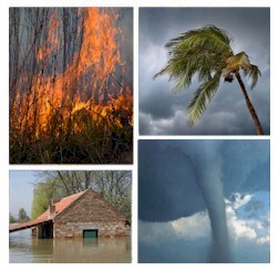
The 911Broadcast emergency notification and alert service can deliver a large number of phone calls using a network of phone systems employing digital phone lines simultaneously. Should a disaster such as a snow storm, wild fire or flood hit your area, 911Broadcast systems can alert your community quickly providing specific instructions if an evacuation is required.
This service is available using our emergency broadcasting systems. If a dangerous chemical spill occurs in your community, you can target specific areas to call. If a severe snow storm hits your area, your community can be notified of school closings or event cancellations.
Predicting the Flood: A Watershed-Specific Alert System
By Amos Clark and Brandon R. Finch
Hydrologic models, radar technology, and historical rainfall data help pinpoint where and under what conditions flooding is likely.
No matter where you live in the United States, you will experience a season at some point wrought with torrential rain and excessive flooding. Strong storms can occur in the spring or summer, and if you live on the coast there also is the chance for tropical storms and hurricanes that can span well into November.
Most people believe storms with high winds and close proximity to the ocean are the ones that cause injuries, deaths, and so much devastation to property. But more than half of the tropical-storm-related deaths that have occurred in the last 30 years did not take place at the coast and were not caused by high winds. They occurred when strong storms came inland and caused flooding.
 In 1999, Hurricane Floyd pounded the East Coast. Of the 56 people who died, 50 drowned because of inland flooding. In 1955, Hurricane Diane caused inland flooding in Pennsylvania, New York, and New England, which contributed to 200 deaths and $4.2 billion in damage. About 23% of US tropical storm deaths happen when people drown driving through flooded areas. It only takes 6 in. of fast-moving water to sweep a person off his or her feet and as little as 1 ft. of water to move most cars.
During strong convective and tropical storms, an incredible amount of water can fall in a relatively short period of time, with most freshwater flooding occurring in less than an hour. During the spring and summer 2003, numerous flooding events occurred in central North Carolina as a result of strong, convective storms.
Each individual river and stream reacts differently to different kinds of storms. Just as no two humans have identical fingerprints, no two watersheds react the same way. Continuous soaking rain over a period of several days is the cause of most large river flooding. Intense rainfall events, such as convective thunderstorms, affect the small-to-medium watersheds. While large rivers might give some notice of an impending flood (which is predictable by looking at upstream flooding conditions), smaller watersheds often flood with little or no advance warning. Flooding scenarios such as this can lead to serious injuries, accidents, property damage, and in some cases death.
Local governments and emergency management professionals are unable to predict which storms will cause flooding. Networks of stream gauges (the historical version of a flood alert system) can indicate a flood wave moving downstream, but only after flooding already is in progress. More time is needed in most cases for emergency management professionals to react effectively. During a flooding situation, local governments and emergency management professionals can either overallocate or underallocate resources and personnel, potentially wasting precious finite resources that could be better used elsewhere. Additionally, property owners (and their insurance companies) typically have little time to react to an impending flood and often are caught helpless while severe property damage and loss are occurring.
Developing a Flood Alert System
 A new type of flood alert system can help local governments and emergency management professionals predict flooding well in advance of the actual event. The John R. McAdams Company, a North Carolina-based design firm, has developed a system that combines real-time Next Generation Weather Radar (NEXRAD) technology with calibrated hydrologic and hydraulic models to determine where and when flooding will occur within a particular watershed.
The first step in developing a flood alert system is to characterize the watershed to create a hydrologic model. Each watershed is unique, and McAdams's stormwater specialists are charged with determining all the factors that give a particular watershed its fingerprint, including physical characteristics, such as soil types, drainage areas, shape of the drainage areas, and flow-path characteristics, in addition to land uses within the watershed. Two of the most important variables are soil types and land use, which correlate the effect of development with the amount of runoff produced.
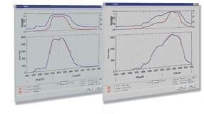
 After the hydrologic model is created, a hydrograph is generated to show how the watershed reacts in a specific storm situation. The hydrograph charts the flow rate of water at any given time during a given storm event. Hydrographs are generated for multitudes of possible storm events, making it possible to later predict the hydrograph from an actual storm as it moves toward an area of interest.
The next step is to construct a hydraulic model to show how a given stream, river, or lake responds to the storm hydrograph input. Among the characteristics modeled are the channel section of the stream, floodplain area, buildings, roadways, and dams. The model then is used to show how the physical environment of the watershed responds to the hydrograph generated by the hydrologic model. It predicts the ways in which water overflows streambanks and floods adjacent areas during the passage of the storm event.
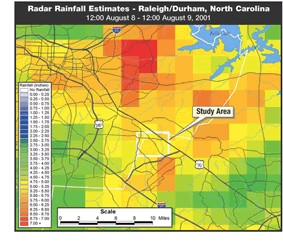
After the hydraulic model is created, McAdams then collects historical rainfall data from OneRain, a US-based provider of both real-time and historical radar rainfall data dating back to 1993. The historical rainfall data are used to calibrate the hydrologic and hydraulic models. This calibration process validates the hydrologic and hydraulic models, verifying that the models actually predict what will happen during a given storm event.
Numerous scenario models then are generated based on multiple variables, including rainfall depth, distribution, and intensity. These models are used to anticipate how different types of storms (distributions, intensities, and so on) will impact the watershed. Hundreds of models are created to pinpoint specific effects of various storm distributions, intensities, and depths.
Each of the various hydrographs generated by this process is input into the hydraulic model for the stream or river. Using output from the calibrated hydraulic model, stormwater specialists can identify and predict where (and potentially when) flooding might occur at any point along the watercourse. Once the owner of the flood alert system is aware of a potential problem, emergency management resources can be dispatched efficiently and areas can be evacuated if necessary.
The initial setup for creating a flood alert system takes approximately six months, with the system being fully operational within approximately a year. These estimates can vary, based on the availability of data and size of the watershed in question. McAdams continues to provide maintenance for the models and easily can step in to recalibrate the model, if needed, and to incorporate increased development that affects the runoff characteristics of the watershed.
The Benefits of Predicting
 The first and foremost benefit for employing a flood alert system is the ability to prevent potential loss of life. If local governments and emergency management professionals are able to know in advance that flooding is likely in a particular location, then roads can be cordoned off, low-lying areas can be evacuated, and people can relocate to safer areas. The system also allows for the efficient mobilization of resources. Local governments can work with other organizations, such as the local chapters of the American Red Cross, to provide shelters for people who need to be evacuated. Emergency management professionals can be stationed in particular locations rather than patrolling large areas. This ultimately saves taxpayers money because resources are not being overallocated or underallocated.
By predicting potential flooding problems, a town or a city might gain valuable insights that could shed light on a fixable problem. For instance, if there is an issue involving an overburdened dam, having the information about how various types of storms affect that particular structure can illustrate what repairs or modifications are needed to prevent failure. This also applies to roadways. The analysis during the construction of the models will highlight weaknesses in the physical system.
The final benefit is that the flood alert system is a proactive way of addressing potential flooding issues. Local governments and emergency management professionals no longer have to play a reactive role once flooding already has occurred or is occurring.
Local government agencies can benefit from employing a flood alert system, but there are a couple of other audiences that could benefit as well. Large commercial developers who currently are located within a floodplain can use the flood alert system to prevent further damage from flooding in future storm events. Insurance companies might also use the system; for example, if a company insures a retail business that is located in a floodplain, it can alert the client before flooding occurs so that preventative measures can be put into place, such as sandbags and merchandise removal. This ultimately will reduce the number of claims and losses and can prevent increased premiums.
There is another use for the fundamental components of the flood alert system. Approached from another angle, the models can be used for forensic studies. McAdams's stormwater specialists can take a known flooding event and, by using calibrated hydrologic and hydraulic models along with historical radar rainfall data, can determine why the flooding occurred and whether anything can be done to prevent future flooding problems.
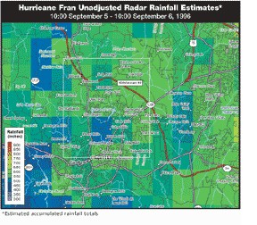
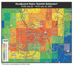
An example is the flooding of a popular shopping center in Chapel Hill, NC, in July 2000. The shopping center is located directly over a watershed that has a history of flooding. In 1996, the shopping center flooded because of Hurricane Fran, with an estimated $7.3 million in damage. On July 23, 2000, the shopping center endured almost 8 in. of intense rainfall throughout the night and early morning hours, causing close to $10 million in damages and $7.3 million in commercial losses.
About 75 apartments, several homes, and all of the 28 businesses at the shopping center sustained damages. By using the same fundamental approach, McAdams was able to determine the weakness of the physical drainage system and pinpoint the major contributor to the flooding. And although many people considered Hurricane Fran to be a 100-year event in this area, in reality it was more on the order of a 10- to 25-year event. This particular study illustrated just how important calibrated models, accurate rainfall distribution, and depth estimates are and how they impact the final result of a project.
Amos Clark, P.E., is the director and Brandon R. Finch, P.E., is a project engineer in the Stormwater Management Group of The John R. McAdams Company in Charlotte, NC
Floods - Emergency Dialer For Flood Warnings
 Should a flash flood threaten your community, our phone services could help warn your neighborhoods of this disaster. With our emergency notification phone service, you can broadcast warning messages to thousands of households in your community warning of catastrophic disasters including flash floods.
Messages can be simultaneously delivered in just minutes using our network of phone systems and services. Pre-recorded warning messages can be played giving households information regarding the flood location and whether a community evacuation is planned or necessary. You can send a broadcast warning to specific neighborhoods or communities in the event of a flash flood and provide priority delivery of these messages to those nearest the flood danger.
Multiple messages can be delivered to different members of the community based upon proximity to the flood.
Calls can be directed to operators that are standing by to handle special individual emergencies.
Messages can also be broadcast seeking volunteers or special assistance from emergency personnel.
|